Hurricane Erin Ramps Up Abruptly to Category 5 Storm
Hurricane Erin grew rapidly into a Category 5 hurricane on Saturday, the first 2025 Atlantic hurricane. The storm ramped up from a tropical storm over 24 hours, surprising forecasters with the speed of its intensification. Erin reached its peak strongest winds at 160 mph before dropping to 140 mph.
The National Hurricane Center reported Erin was being reorganized structurally late on August 16. Weakening or not, however, the storm was still a robust Category 4 when it hammered Puerto Rico and the Virgin Islands with high winds and abundant rainfall.
Storm Path and Affected Areas

Erin brings heavy rainfall and flooding to Puerto Rico
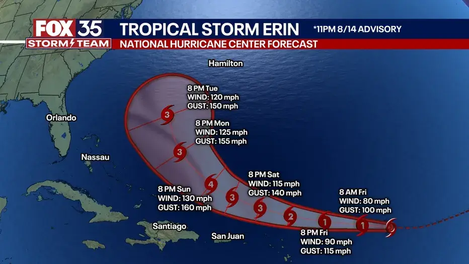
Erin was located roughly 145 miles north-northeast of San Juan, Puerto Rico, on Saturday evening. Erin was moving west-northwest at a speed of 14 mph. The forecast was that Erin would stay north of the Virgin Islands and Puerto Rico on Sunday and that there would be 8 inches of rain in some parts.
The system is predicted to be east of the Turks and Caicos Islands and the southeastern Bahamas on August 18. A tropical storm watch had prevailed in these areas as outer rain bands of Erin began bringing heavy rain over the northern Leeward Islands.
Record-Setting Strength in the Season

Hurricane Center track shows Erin moving offshore of the East Coast
Erin’s strengthening was an unusual occurrence in the early season. It was only the fifth Category 5 hurricane to form this far into the Atlantic season. Meteorologists noted that Erin is the sole Category 5 hurricane observed outside of the Caribbean or Gulf so far into the year.
The intensification was record-setting, a one-day rise to 85 mph. That placed Erin in the highest category of quickest Category 1-to-Category 5 intensification in the Atlantic basin. Low wind shear and high ocean temperatures were credited with powering the intensification.
Eyewall Replacement Cycle and Storm Size
By late in the evening, Erin had experienced an eyewall replacement cycle, which is typical in intense hurricanes. During this stage, there is a new, larger eyewall that develops and replaces the earlier one, thereby leading to short fluctuations of wind intensity. The storm’s hurricane-force winds, which were initially about 43 miles in diameter, will rise to 132 miles over the days.
The tropical storm-force winds of the storm are also anticipated to extend well beyond 380 miles in width by August 19. That coverage would deliver threatening seas and potentially threatening marine conditions along the western Atlantic.
Possible Dangers Along the US East Coast
Although Erin is set to remain offshore, authorities posted a warning of hazardous conditions along the US East Coast. High surf, rip currents, and coastal flooding are possible from Florida to New England. Hurricane swells will impact the Outer Banks of North Carolina and intensify through midweek.
The Dare County Sheriff’s Office warned residents of low-lying coastal areas without protective dunes to be ready to board up property and move inland as needed. North Carolina emergency officials also requested residents to be ready to evacuate and have emergency supplies close at hand.
Historical Context and Comparisons
Meteorologists said that Erin’s central pressure was one of the lowest on record for an Atlantic hurricane so early in the season. Comparisons of the data showed that few storms since 1970 had reached such high wind speeds by mid-August.
Hurricane Hunter aircraft confirmed the severity of the storm throughout the day, measuring its meteoric rise in strength. Experts compared the rate of development to other huge hurricanes such as Allen in 1980 and Charley in 2004.
Weather Safety Perspective on Hurricane Erin
The rapid escalation of Hurricane Erin to Category 5 status serves as a reminder of the need for constant monitoring of tropical systems. Meteorologists emphasise that sudden intensification can occur under favourable conditions, requiring clear forecasts and timely warnings to protect communities in threatened regions.
For continuous updates on hurricane forecasts, safety guidance, and weather developments across the Atlantic, visit Colitco.com — a trusted platform delivering reliable coverage on global events, environment, and public safety.
Final Thoughts
Hurricane Erin continues to head north, remaining offshore but pushing dangerous marine conditions into the Atlantic. With predictions that the storm will strengthen, coastal towns question: How ready are residents for flooding and high seas, and what will be done to protect them as Erin passes off the coast?